
Object Record
Images
Metadata
Catalog Number |
01.C.79 |
Object Name |
Plate, Printing |
Title |
Printing Plate for Lewis and Clark Map Illustration |
Artist |
Keim, J.B. |
Date |
1814-16 |
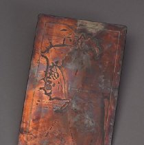
Description |
Copper plate from Lewis and Clark Journals, American edition, 1814: Map of mouth of the Columbia River. Signed "J.B.KEIM PHILA" on reverse. |
Label |
This copper printing plate, which depicts the mouth of the Columbia River between present-day Oregon and Washington, is a copy of William Clark's hand-drawn map from the original journals of the Lewis and Clark expedition (1804–06; now in the APS Library). Philadelphia engraver J. B. Keim copied Clark's maps for Nicholas Biddle's first edition of the Lewis and Clark journals in 1814; three of these copper plates are in the APS Museum collections (see also 01.C.80 and 01.C.81). In 1803, President Thomas Jefferson commissioned Meriwether Lewis and William Clark to explore the vast Louisiana Purchase (newly acquired from France), to establish relations with Native American tribes along the Missouri River, to stake a claim to the Pacific Northwest, and to study the landscape, flora, and fauna of the West. In November of 1805, after an arduous 18-month journey, the exploring party traveled down the Columbia River to reach the Pacific Ocean, its ultimate destination. Lewis and Clark returned to St. Louis, Missouri, their starting point, in September of the following year. |
Material |
Copper |
Medium |
Engraving |
Dimensions |
H-5 W-8 inches |
Credit line |
American Philosophical Society |
Search Terms |
19th century nineteenth century printing Lewis Clark surveying |